云阳沙滩与水上花园
Yunyang Beach and Water Garden
-
项目位置:重庆云阳
委托单位:云阳县政府
面积:4.4ha
设计时间:2014-2015年
建成时间:2016年
获奖:2018年英国国家景观协会(BALI)国家景观奖
2018年国际风景园林师联合会亚非中东地区(IFLA AAPME)设计杰出奖
2019年中国风景园林学会科学技术奖规划设计一等奖
-
Project location:Yunyang, Chongqing Municipality
Clients:The government of Yunyang County
Area:4.4ha
Design year:2014-2015
Year Built:2016
Awards:
2018 BALI National Landscape Award
2018 IFLA AAPME Outstanding Award
2019CHSLA Design & Planning Award (1st Prize)


重庆市云阳县位于世界最大的水利工程——三峡水库岸边,老县城已经淹没于水库之下,新县城于 1992年在现址开始建设,随着城市化的发展,目前已经拥有了 20 多万人口。
Yunyang County town is located on the bank of Three Gorges Reservoir, the largest water conservancy project in the world. As the old county seat has been submerged under the reservoir, the new county town began to be built on the present site from 1992. With the urbanization process, it has owned a population of more than 200,000 today.
按照新县城的规划,城市滨水地带是连贯的公园绿地。但在县城的发展过程中,虽然也建成了一些公园,但是仍有不少原本规划的绿化用地被侵占,建造了居住区、宾馆、码头、仓库等等。几个公园被这些建筑分隔开,无法联系为一个整体。并且,这些公园建造于 20 年前,原本设计就不够完善,建造仓促,设施已陈旧不堪,今天来看无论从美学上还是社会功能上都不能令人满意。
According to the urban general plan, some parks have been built along the waterfront area of Yunyang. Since many riverside area has been occupied by residential areas, hotels, wharves, warehouses and etc., the parks were failed to be connected. Moreover, these parks, more than 20-year-old, are no longer satisfactory neither aesthetically nor functionally, with inappropriate previous design and outdated facilities.
与三峡库区的其他城市一样,水库既给云阳带来了独特的风景,也带来了许多问题。三峡水库的修建使得原来波涛汹涌的长江成为风平浪静的带状湖泊,倒影着周围山峦,风光秀丽。水库冬季蓄水,春夏泄水,最大水位差有 30 米,形成了全世界最大的消落带。水位下降后,沿岸会裸露出大片的土坡,很多地方宽度超百米。并且,为了防止塌方和水土流失,许多岸线都做了工程处理。在枯水期,城市滨水岸边会露出大片的土坡和人工驳岸工程,既影响景观,又隔离了城市与长江。
Like other cities on the banks of Three Gorges Reservoir, Yunyang enjoys the unique scenery brought by the reservoir construction on the one hand, but has to tolerate various problems caused by the reservoir on the other. The construction of Three Gorges Reservoir transformed the previously turbulent Yangtze River into a calm belt-lake which mirrors the surrounding mountains, created charming scenery. As the reservoir stores water in winter and discharges in spring and summer, the maximum water level difference reaches 30 meters, forming the largest hydro-fluctuation belt in the world. When the water level drops, large earth slopes or engineering work with the width normally more than 100 meters along the bank would be exposed, not only have negative impact on landscape, but also separate the city from the Yangtze River.
云阳县政府希望能够改变城市滨水地区的景观,充分利用水边现有公园绿地、闲置荒地、山坡地,并考虑合理利用面积巨大的消落带,建设一条连续的城市滨水绿道和公园系统。我们对城市 33 公里长的水岸进行了整体规划,提出一系列策略,旨在加强城市与水岸的联系,改善滨水景观质量,建立连贯的慢行系统,提供多种城市功能,创造富有活力的城市滨水空间。之后,我们又设计了靠近城市中心的这部分地块作为整个项目的启动。
With the hope to transform the landscape of the urban waterfront area, the local government plans to build a coherent urban waterfront greenway and park system by taking advantage of the existing park, wasteland and hillside land, and making rational use of the huge hydro-fluctuation area. Landscape architects made an overall plan for the 33 kilometer-long urban waterfront area, put forward a series of strategies aiming at strengthening the connection between the city and the waterfront, improving the quality of waterfront landscape, establishing a coherent slow-traffic system, and providing a variety of social functions to create vibrant urban waterfront open spaces. Afterwards, the specific site under the Yangtze River Bridge and near the center of the city was designed as the launch of the whole project.

这个地块位于城市最大的滨江公园江堤的外侧,大部分是水库消落带,云阳对外交通联系的主要通道——雄伟的长江大桥从上方飞架而过。场地原本是山地,地形高低起伏,随着每年水库水位的变化,呈现出不同的陆地形态和面积。时而连成一片,时而成为分离的多个岛屿和半岛。
The site is located outside the river bank of the largest riverside park in the city, and mostly belongs to the hydro-fluctuation belt. Yangtze River Bridge, the main passageway of Yunyang's external transportation, runs above the site. Having a rugged topography, the site presents different land forms and related acreages with the yearly water level fluctuation of the reservoir, sometimes being a continuous land surface and sometimes separated into several islands and peninsulas.
西侧消落带顶部有面积较大的缓坡地,由于高程较高,一年中露出水面的时间较长,于是人们将其部分硬化,设置了简易的游泳池、旱冰场和小广场,在水位下降时使用。虽然设施简陋,会在冬季淹没,但因为云阳缺乏类似活动场地,这里还是一个比较受青少年欢迎的活动空间。
There exists an extensive gentle slope at the top of the west part of site. Because of the relatively high elevation, it can be exposed above the water surface for relatively longer period every year. Thus, it was partly concreted for simple swimming pool, roller skating field and small plaza, which can be available when the water level drops. Although the facilities are simple and would be submerged in winter, the site didn’t fail to become a popular open space especially for the youths, as Yunyang extremely lacks space for outdoor activities like this.
东侧有 1.4 公顷的土地常年位于最高水位以上,突出于江堤之外,成为一个半岛。由于它位于长江大桥的正下方,长期被人遗忘而荒置,杂木杂草丛生。其余大都是会被季节性淹没的坡地,只有最东端坡顶比水库最高水位略高一些,在高水位期会成为一个很小的江心洲。
On the east side, about a 1.4-hectare-area land is located above the highest water level all year round, protruding beyond the river bank as a peninsula. As it lies below the Yangtze River Bridge, the site has long been forgotten and abandoned. Around the peninsula are mostly seasonally submerged slopes, with only the easternmost slope top slightly higher than the highest water level, becoming a small island in the middle of the river during high water level periods.
由于滨江公园本身已经提供了连续的步道,大量的植物和一些广场和休息设施。设计师希望新设计的地块能够作为老公园功能的补充,提供更好的设施和环境,更为开敞的景观,与长江建立更加紧密的联系。
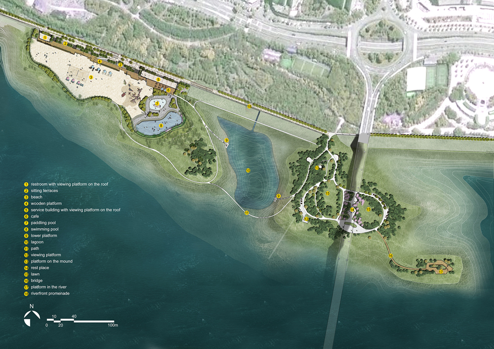
设计保留了西侧地块原有的运动功能,通过垫高 1-2m,使之高于水库的最高水位,这样可以设置永久性体育活动设施和服务设施,常年使用。功能上,一侧设计了游泳池和戏水池,创造了城市的水上活动中心。
As for the western part, the original function for sports is reserved. By elevating the ground about 1-2 meters, the site elevation is above the highest water level, thus permanent sports and service facilities are available for all-year-round use. A swimming pool and an paddling pool aquatic
其余部分设计了大面积的沙滩,可以进行儿童游戏、沙滩足球、沙滩排球等活动,为孩子们提供了一个尽情玩耍的地方。原有的工程驳岸转变成一系列的景观设施,成为上下两层公园联系的纽带。利用驳岸的高差设置服务建筑,为下层公园提供了更衣、厕所、售票、咖啡、小卖等功能,而建筑顶部成为视线开敞的上层观景平台。一部分原有驳岸通过改造,成为看台式座凳,中间穿插布置绿地花池,种植高大荫浓的乔木和常绿灌木,形成舒适的观景和休息区域。沙滩边缘的木平台和木质躺椅创造了舒适惬意的休闲气氛。沙滩的设计不仅满足了不同人群的活动需求,成为一处全民休闲的乐园,而且与云阳的历史紧密联系。云阳县城在搬迁之前与长江关系紧密,江边上有大片的滩涂沙地。沙滩的设计在某种程度上是对云阳历史的一种记忆,弥补今天新的城市与水岸之间只有面积巨大的消落带的遗憾。
playground are designed on one side, creating a water sports center for the city. And the rest part is designed as a large area of beach, allowing activities such as children’s playing, beach football, beach volleyball etc., providing citizens a space for outdoor recreation. The service buildings provide such functions as locker room, restroom, ticket service, cafeteria, canteen etc., while their roof become the viewing platform with broad vision over the beach and the river.The previous revetment is partly transformed into bleacher-style benches seaitting terracess, which is interspersed with planting areas containing shady trees and evergreen shrubs, become a comfortable space for viewing and rest.Wooden platforms and lounger-like benches on the edge of the beach create a comfortable and cozy atmosphere.The beach not only meets the needs for a popular leisure place, but also recalls the history of Yunyang. Before relocation, with the beach along the riverside, the old county town had tightly related to the Yangtze River. To some extent, the design of the beach could make up for the regret of huge hydro-fluctuation belt in today’s city waterfront.


长江大桥下方的半岛,三面环水,有良好的外向视线,设计师将其转变为一处自然风格的水上花园,中心是以春花小乔木和秋叶植物为背景的开敞草地,周边沿水岸布置系列休息平台,向内可观赏草地,向外可赏江景。大桥下方设计为休息锻炼的场地。整个公园地形舒缓起伏,利用原有土丘设置观景台一处,可以俯瞰花园,眺望长江,仰望宏伟的长江大桥。
The peninsula below the Yangtze River Bridge, surrounded by water on three sides and owns a great outward view, is turned into a natural-styled garden. The center of the garden is an open lawn with spring-flowering arbors and autumn-coloring plants in background. A series of platforms are arranged along the waterfront to provide the sight of the lawn inwards and of the river scenery outwards. The topography of the park is gently undulating, with a viewing platform set up on the existing mound, on which people can overlook the park and the Yangtze River, and look up at the magnificent bridge.


在东侧小岛上设计一处水上平台,以栈道与半岛连接。这个四面邻水的平台如同一艘停泊在江面的驳船,是体验浩淼长江景色的绝佳场所,也提供了从水面观赏城市景观的独特视角。
A platform is designed on the easternmost island, connected to the peninsula with a curve bridge.The platform surrounded by water, like a barge moored on the river, is an excellent place to experience the landscape of the Yangtze River and meanwhile it provides a unique urban landscape from the river.


在高水位时,沙滩和水上花园被水面隔开,相互独立,依靠滨江步道连接。低水位时,两个部分连接在一起。为了充分利用消落区,在消落带设计了一条小路和一些亲水平台,水位下降时小路可以连接两个部分。从这条小路步行,人们能够更接近长江之水,也可以休息和眺望。利用原有地形,设计了一个小泻湖,水库水位下降时,泻湖还可以在靠近驳岸的地方保留一片水面,丰富景观,增加滨江步道的亲水感。每年春夏季节水位下降以后,消落带会自然萌发一些乡土草本植物覆盖裸露的地表,我们认为保留这种自然状况是最佳选择,因此在消落地带风景园林师尽量保留了原有地形,只是在改造区域采用生态型和景观化措施进行驳岸加固,避免水位下降之后暴露工程措施对景观造成破坏。
During the high water level period, the beach and the garden are separated by water, while during the low water level period, the two areas would connect together. To make full use of the hydro-fluctuation zone, a path and two platforms are designed in the zone. When the water level drops, people can get closer to the river by walking through the path, take a rest and enjoy the scenery on the platform. A small lagoon is designed based on the original topography, so as to retain some water area near the river bank in low water level periods, would enrich the landscape experience on the riverside. With the water level drops in spring and summer, some native herbs could spontaneously germinate on the bare surface of the hydro-fluctuation zone. Landscape architects believe that to preserve this natural process is the best choice for such special area. Therefore, the existing topography was preserved as much as possible in the hydro-fluctuation zone, ecological and landscape measures were only conducted in the constructed areas to reinforce the revetment.

通过对城市滨水的消落带土地和荒弃土地的充分利用,云阳沙滩和水上花园为城市创造了新的公共空间,提供了广受欢迎的活动内容和设施,提高了城市的生活品质。该设计适应于水库水位的变化,呈现出弹性的景观,也可以弹性地使用。水上公园为云阳沿线 33 公里的水岸线的景观改造和绿道建设提供了样本,也为三峡水库沿岸其他城市消落带的处理提供了参考。
Through the full use of the hydro-fluctuation belt and wasteland in the waterfront area of a reservoir-side city, Yunyang Beach and Water Garden create new public spaces, offer popular activities and facilities for the citizens. Adapting to the change of reservoir water level, the design presents resilient landscapes and offers resilient functions. It recreates the relationship between the city and the Yangtze River, provides a sample for the waterfront green belt of Yunyang, and also offers a reference for other cities along Three Gorges Reservoir who intends to deal with the hydro-fluctuation belt.


Team:Li Liang、Liu Tong、Zhang Shiyang、Zheng Xiaodong、Li Yang、Zhang Mingran、Yangchun Baixue、Hua Rui、Ren Wei、Jin Jiaxin、Wang Xuan、Xu Lu、Han Yu、Chang Hong、Zhao Zhenzhen、Du Hongjuan、Li Kang、Wang Yuhang、Zhang Xuewei、Yuan Jing、Liu Jingyi、Duan Shile